
Leveraging Earth Observation Data to Revolutionize Agricultural Insurance in Africa
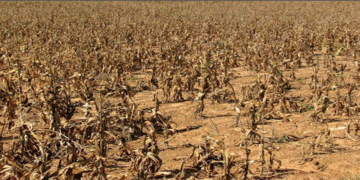
In the dynamic landscape of agricultural insurance, African insurers face unique challenges ranging from data scarcity to the impacts of climate change on crop yields. However, the advent of Earth observation (EO) data presents a transformative opportunity to address these challenges and enhance the efficiency and effectiveness of insurance services in the agriculture sector.
Addressing Data Challenges with Satellite Technology
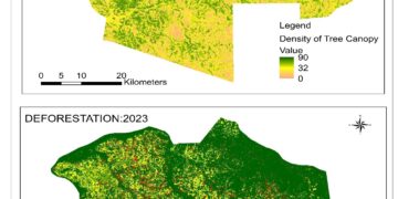
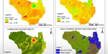
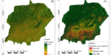
One of the foremost hurdles for insurers is the lack of organized and comprehensive data about agricultural fields, crucial for risk profiling and pricing. Traditional methods like crop-cutting experiments are expensive and not scalable. This is where satellite data emerges as a game-changer. By integrating satellite analytics with traditional methods, insurers can now cover larger areas with greater accuracy, providing essential data on crop health, growth stages, and field conditions. Moreover, satellite technology offers access to weather statistics and historical data on soil moisture levels, empowering insurers to create precise risk maps for underwriting.
Streamlining Operations and Enhancing Transparency
High operational costs, time-consuming claim validation processes, and the need for constant policy review due to climate change-induced risks further challenge insurers. Satellite data analytics offers a solution by enabling near real-time monitoring of geographically dispersed croplands, simplifying risk assessment, and automating claim validation. This not only reduces costs but also enhances transparency, enabling insurers to provide better services to their clients.
Two Approaches to Integration
The integration of EO data into insurers’ workflows can follow two primary approaches. The first involves utilizing EO data for a standalone Crop Monitoring platform, offering a centralized repository of agricultural data for insurers and clients. This fosters transparency standardizes underwriting processes, and facilitates efficient claims management. The second approach focuses on leveraging satellite and weather data to create or enhance index insurance products, enabling better risk management and tailored solutions for agribusiness clients.
Integrating Crop Monitoring into Workflow
Consider a scenario where a client reports a loss of yields due to an insurable event. Using EO Crop Monitoring data, insurers can swiftly verify the claim and assess the damage. The technology allows for remote verification of damage, reducing the need for field visits and expediting the claims process. Additionally, insurers can prioritize field visits based on the severity of the event, optimizing resources and ensuring accuracy in claim verification.
Future Opportunities with New-Generation Technologies
While satellite data has been transformative, advancements in new-generation technologies promise even greater benefits for insurers in Africa. Integration of artificial intelligence enables highly accurate yield predictions by analyzing historical data. Furthermore, upcoming Earth observation satellite constellations, such as EOS SAT, will provide higher-resolution imagery and expanded spectral bands, enhancing data quality and coverage. Additionally, the use of Synthetic Aperture Radar (SAR) satellites will ensure consistent data acquisition regardless of cloud cover, further bolstering insurers’ capabilities.
Generally, Earth observation data represents a pivotal tool for African insurers in revolutionizing agricultural insurance. By harnessing the power of satellite technology and embracing new-generation advancements, insurers can enhance risk management, streamline operations, and provide more resilient and sustainable insurance services to the agricultural sector. As climate change continues to pose challenges, EO data stands as a beacon of hope, enabling insurers to navigate uncertainties and build a more resilient future for agriculture in Africa.