Satellite-based augmentation Systems (SBAS) have emerged as a powerful technology with the potential to revolutionize various sectors in Africa. SBAS, which enhances the performance of global navigation systems like GPS, GLONASS, Galileo, and Beidou, offers numerous benefits such as improved accuracy, integrity, availability, and continuity of navigation signals. While SBAS’s primary application lies in aviation, it has significant implications for other domains, including agriculture, maritime, land management, and transportation. This article explores the significance of SBAS in Africa and its potential to drive socio-economic development across the continent.
The Concept of Global Navigation Satellite System (GNSS)
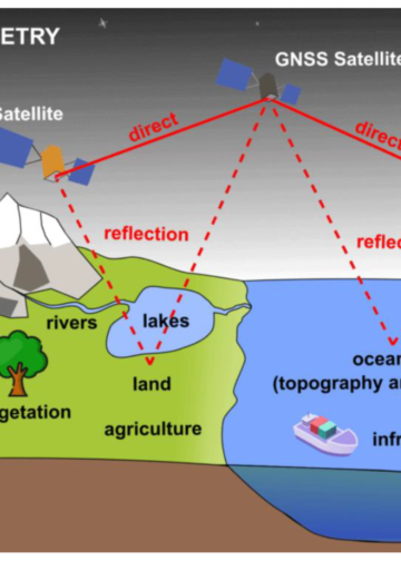
GNSS technology enables users with compatible receiver devices to ascertain their precise position, velocity, and local time by processing signals originating from satellites distributed across the celestial expanse. These GNSS signals emanate from vital satellite systems known as core constellation systems. Presently, the principal core constellation systems encompass the United States’ Global Positioning System (GPS), Europe’s Galileo, Russia’s Global’naya Navigatsionnaya Sputnikovaya Sistema (GLONASS), and China’s Beidou.

DGNSS, RTK, PPP,
Advanced technologies such as Differential GNSS (DGNSS), Real-time Kinematics (RTK), and Precise Point Positioning (PPP) play a pivotal role in enhancing the accuracy of these core constellations. Concurrently, technologies like Aircraft-based Augmentation Systems (ABAS), Ground-Based Augmentation Systems (GBAS), and Satellite-Based Augmentation Systems (SBAS) not only bolster accuracy but also provide integrity, denoting the reliability and trustworthiness of the information.

Aircraft Based Augmentation Systems (ABAS)

Ground Based Augmentation Systems (GBAS)
The utilization of GNSS Position, Navigation, and Timing (PNT) data hinges upon specific operational requirements and spans diverse sectors, including Aviation, Maritime, Road and Rail transportation, Agriculture, Consumer Location-Based Services (LBS), Geospatial Information, Timing and Synchronization, as well as applications in Drones and the Internet of Things (IoT) realm.
SBAS Systems Around the World

Satellite Based Augmentation Systems (SBAS)
Several countries and regions have recognized the value of SBAS and have deployed or are in the process of deploying their systems. These systems include the Wide Area Augmentation System (WAAS) in the United States, the MTSAT Satellite-based Augmentation System (MSAS) in Japan, the GPS Aided GEO Augmented Navigation (GAGAN) in India, the System of Differential Corrections and Monitoring (SDCM) in Russia, and the European Geostationary Navigation Overlay Service (EGNOS) in Europe and Northern Africa. China has also expressed its intent to augment the Beidou navigation constellation with an SBAS system for Asia.
Expanding SBAS to Africa
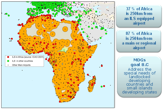
Extending SBAS services to cover the entire African continent holds immense promise. Such an expansion would not only benefit Safety-of-Life Services in aviation and maritime but also improve accuracy in domains like agriculture, land management, and transportation. EGNOS, as the first European SBAS, has demonstrated the potential of SBAS to enhance satellite navigation systems. EGNOS has been operational since 2011, certifying its service provider in July 2010. It has already led to the implementation of numerous aviation procedures and plans for further development.
EGNOS potential added value for regional integration

EGNOS potential added value for regional integration
The Opportunity for Africa
The upcoming upgrade of EGNOS to EGNOS V3, featuring multi-frequency (L1/L5) and multi-constellation (GPS, Galileo) support, presents a unique opportunity for African nations and Regional Economic Communities (RECs). EGNOS V3’s expanded footprint already covers the African continent, and the necessary ground facilities can be easily installed on African territory. This upgrade aligns with international standards, making it a cost-effective solution for Africa to enhance its navigation infrastructure.
Applications and Benefits
The benefits of SBAS expansion in Africa are manifold:
- Aviation: SBAS systems enhance aviation safety, reduce delays, and expand air transport coverage, including remote regions. This can lead to increased inter-regional connectivity, commercial opportunities for airlines, and reduced CO2 emissions.
- Rail: SBAS eliminates the need for costly track-side infrastructure maintenance, fostering rail network expansion and cost savings.
- Maritime: SBAS services improve efficiency and safety in water transportation, supporting the development of inland waterways networks and aiding in Search and Rescue (SAR) operations.
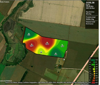
- Agriculture: SBAS enhances agricultural productivity by providing precise tractor guidance, reducing input costs, and contributing to poverty reduction.
- Land Management: SBAS improves cadastral management and accuracy for rural parcels, supporting economic development and the rule of law.
Supportive Policies and Initiatives
SatNav Africa Joint Programme Office (JPO)
JPO’s mission is “As a Pan African specialized ‘entity’ to support the implementation of seamless and sustainable satellite navigation services in all sectors with aviation as the main driver.”
The SatNav Africa JPO champions the development of Satellite Navigation (GNSS/SBAS) services in Africa based on European solutions EGNOS and Galileo. As a component of the Joint Africa-EU Strategy (JAES), JPO promotes the implementation and use of GNSS/SBAS in various market segments.
JPO strategic areas of intervention include support to GNSS/SBAS services Implementation and; applications development; promotion and communication; Training and capacity building and R&D-specific support services in the future.
Capacity Building and Implementation
To facilitate SBAS implementation, capacity-building initiatives have been undertaken. Projects like SAFIR and TREGA, funded by the European Commission, have trained African personnel and developed a comprehensive implementation roadmap for EGNOS in Africa, emphasizing regional approaches.
Ongoing Research and Development
Research and development projects, such as SIRAJ, ESESA, SATSA, and MAGNIFIC, have been instrumental in exploring alternatives for providing SBAS services in African regions. These projects involve collaboration between European and African stakeholders, ensuring that the benefits of SBAS technology reach African communities.
Satellite-Based Augmentation Systems (SBAS) have the potential to catalyze economic and social development across Africa. By expanding SBAS services to cover the continent, African nations can improve safety, efficiency, and productivity in aviation, rail, maritime, agriculture, and land management. Supported by policy initiatives and capacity-building efforts, the integration of SBAS technology is poised to be a transformative force, connecting Africa with global navigation systems and unlocking a future of progress and prosperity.


